
MAPS & VIEWS
PRINTS
BOOKS
back to search results place the mouse over an image to zoom
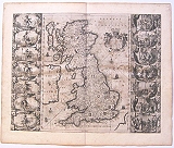
The Anglo Saxon Heptarchy.
"N. Visscher excudit." Great Britain. "Britannia prout divisa suit temporibus Anglo- Saxonum, præsertim durante illorum Heptarchia.." Amsterdam. J. Janssonius. 1649Copper engraved map of the Anglo Saxon Heptarchy by Janssonius. from "Le Nouveau Theatre Du Monde Ou Nouvel Atlas " Vol black & white ;F rench text to verso.
This highly decorative map by Jansson shows the British Isles at the time of the Anglo-Saxon Heptarchy; the seven ancient kingdoms of Kent, the South Saxons, West Saxons, East Saxons, Northumberland, East Anglia and Mercia
The map is embellished with border panels depicting the seven kings in full battle dress & armor, and with scenes illustrating the conversion of each of the seven kingdoms to Christianity in wake of St. Augustine's arrival in England in the year 597 A.D.
Based on the map by John Speed, both Blaeu (1645) and Janssonius (1646) produced the map for their atlases of the British Isles. Janssonius' edition can be distinguished from Blaeu's by the addition of radiating compass lines to the sea. Good dark impression; lightly toned as so often with Janssonius' maps; scattered foxing/ spotting , darker in places; small worm hole to centre of map at centre fold
The map has been trimmed to plate mark and stuck down to the page, covering the map "Anglia Regnum" obviously a mistake of the printer , who had already printed the letterpress to the verso; [ this can be seen as the map has become loose at upper right]. Un restored.
Johannes Janssonius (approx. 1588-1664)
came from a family of printers and publishers and learned the book printing trade at an early age. In 1612 he married the daughter of Jodocus Hondius and thus became a member of one of the most important publishing families in the Netherlands. During the 1630s he went into partnership with his brother-in-law Henricus Hondius and published more editions of the Mercator/Hondius atlases with the addition of the name Jansson. He grew their publishing house in the fields of geography and cartography and published newly compiled world, sea and city atlases, always competing with the Blaeu publishing house. His main works were the "Atlas Majoris Appendix" (1639), the six-volume "Atlas Novus" (1638 ) and the monumental "Atlas Major" comprising eleven volumes (1647).
Shirley, Early printed maps of the British Isles, 577. 420 by 530mm (16½ by 20¾ inches). ref: 3258 €2600
Company: Bryan, Mary Louise.
Address: Ag. Andrianoy 92 , 21 100 Nafplio, Greece.
Vat No: EL 119092581