MAPS & VIEWS
PRINTS
BOOKS
back to search results place the mouse over an image to zoom

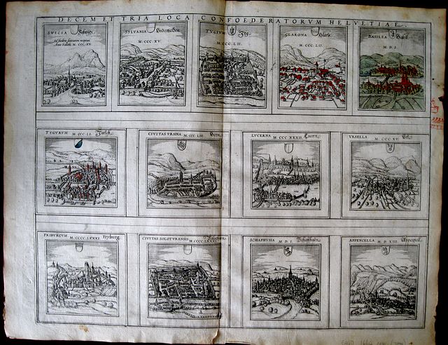
The 13 Cantons of the Old Swiss Confederacy.
Frans Hogenberg & Simon Novellanus` Cantons of Switzerland. "Decem et Tria Loca Confoederatorum Helvetiae. " Cologne Theodori Graminæi. 157213 copper engraved views of the original 13 Cantons of the Swiss confederacy from the first volume of Braun & Hogenberg's "Civitas Orbis Terrarum. " Latin text to verso. First state. 13 views on 1 plate.
The views are: Suicia- Schwytz; Sylvania- Underwalden; Tugium-Zug; Glarona- Glaris; Basilea- Basell; Tygurum-Zurich; Civitas Ursina-Bern; Lucerna-Lucern; Ursella-Uri; Fiburgum- Fryburg; Civitas Soluterensis -Solothurn; Shaphusia- Schaffhussen; Appencella- Appenzell. Each gives the date of joining the confederacy. Good impression; a few light stains, mainly to blank margins; tear at lower centre fold [4cm]; red ink doodle to right margin.
View of Basle with full old colour; Glaris and Zurich with old col
The "Civitas Orbis Terrarum" of Georg Braun and Frans Hogenberg was the first systemstic city atlas, possible intended to compliment the "Theatrum Orbis Terrarum "of Abraham Ortelius published in 1570.
There is strong evidence that Braun, Hogenberg and Ortelius discussed the planned work, although some scholars believe it was influenced by Sabastien Munster's "Cosmographia"
R A Skelton in his introduction to the facsimile edition [ 1965] puts the case f for the "Theatrum " of Ortelius being the model for the work ( "(it) is made abundantly clear by the similarity between the two works in title, in format and in the layout and serial order of the plates and text"
First publishe in 1572 in Cologne just two years after Ortelius' " Theatrum" it was published in six volumes in the years between 1572 and 1617.
Georg Braun [1541-1622], Canon of Cologne Cathedral wrote the preface for all but the last volume and also the text accompanying each plan or view on the verso.
The plates were engraved by Frans Hogenberg and Simon Novellanus after the original drawings of Joris Hoefnagel[1542-1600] who travelled with Ortelius through Italy and also made extensive travels through France Spain and England
Following the death of Frans Hogenberg the plates were engraved by Abraham Hogenberg, believed to be his son.
Jacob Hoefnagel continued the work of his father following his death, particularly the Austrian and Hungarian cities. Other notable contributers were Heinrich Rantzau with maps and plans of northern Europe, especially Denmark and Jacob van Deventer's plans of cities in the Netherlands. .
Braun corresponded with mapsellers and scholars throughout the world and it was his idea to include the figures of local inhabitants in the foreground of the plans and views, This was not just to add "Local colour" but believing the work could be of refence for Military use, particularly by the Turks. the insertion of images of the human form. specifically forbidden by Islam, was intended to prevent this.
Keoman vol2; B&H1/32 365 by 467mm (14¼ by 18½ inches). Each view in upper row approx 98x77mm; 2nd row 100x107mm; lower ro ref: 1664 €450
Company: Bryan, Mary Louise.
Address: Ag. Andrianoy 92 , 21 100 Nafplio, Greece.
Vat No: EL 119092581