MAPS & VIEWS
PRINTS
BOOKS
Miniature Map of the Gulf of Bengal, India.
 Petrus Kaerius/Pieter van der Keere; Jodicus Hondius.
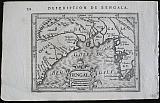
"Description de Bengala." Bengala. Amsterdam Jodicus Hondius Jr. 1616
Petrus Kaerius/Pieter van der Keere; Jodicus Hondius.
"Description de Bengala." Bengala. Amsterdam Jodicus Hondius Jr. 1616Copper engraved map of the gulf of Bengal, India from Petrus Bertius' "Tabularum geographicum contractarum libri septum." French text to verso describing the succeeding map.
Decorative strap work cartouche large fish to sea. Dark impression.
Koeman: Lan 11. 98 by 134mm (3¾ by 5¼ inches). €80
Miniature Map of Gujarat, India.
 Petrus Kaerius/Pieter van der Keere; Jodicus Hondius.
"Description de Cambaie." Cambaia. Amsterdam Jodicus Hondius Jr. 1616
Petrus Kaerius/Pieter van der Keere; Jodicus Hondius.
"Description de Cambaie." Cambaia. Amsterdam Jodicus Hondius Jr. 1616Copper engraved map of Gujurat, India from Petrus Bertius' "Tabularum geographicum contractarum libri septum." French text to verso describing the succeeding map.
The map shows the estuary of the Indus river, and the Cambaia or Kathiawar Peninsular, with the towns of Cambaia, present day Khambhat, Goga (Ghogha), Suratte (Surat), Damaom (Daman) Dio (Diu) etc. Ahmadabad is marked as Ardavat.
Strap work cartouche. Dark impression.
Koeman: Lan 11. 96 by 136mm (3¾ by 5¼ inches). €80
Miniature Map of the Malabar Coast, India.
 Petrus Kaerius/Pieter van der Keere; Jodicus Hondius.
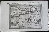
"Description du Royaume de Malabar." Malabar. Amsterdam Jodicus Hondius Jr. 1616
Petrus Kaerius/Pieter van der Keere; Jodicus Hondius.
"Description du Royaume de Malabar." Malabar. Amsterdam Jodicus Hondius Jr. 1616Copper engraved map of the kingdom of Malabar from Petrus Bertius' "Tabularum geographicum contractarum libri septum." French text to verso describing the succeeding map.
The map shows the Malabar coast, India with the islands of the Indian Ocean, including the Maldives. Dark impression.
Koeman: Lan 11. 99 by 134mm (4 by 5¼ inches). €80
Miniature Map of Tartary.
 Petrus Kaerius/Pieter van der Keere; Jodicus Hondius.
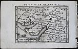
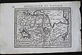
"Description de Tartarie." Tartaria. Amsterdam Jodicus Hondius Jr. 1616
Petrus Kaerius/Pieter van der Keere; Jodicus Hondius.
"Description de Tartarie." Tartaria. Amsterdam Jodicus Hondius Jr. 1616Copper engraved map of Tartary. from Petrus Bertius' "Tabularum geographicum contractarum libri septum." French text to verso describing the succeeding map. Dark impression; printed slightly crooked on page.
Koeman: Lan 10 98 by 136mm (3¾ by 5¼ inches). €60
Famous Figure Map of Asia.
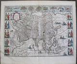 Asia. "Asia noiter delineata Auctore Guiljelmo Blaeuw." Amsterdam Apud Johannem Guiljelmi F. Blaeu. c1655
Original coloured, copper engraved figure map of Asia from volume 2 of Joan Blaeu's "Theatrum Orbis terrarum, sive atlas novus .pars secunda." Double page; folio; Latin text to verso.
The famous figure map of Guillaume Blaeu has 9 town views in upper border and 10 costumed figures in side borders, there are numerous galleons and monsters to the sea; a large elephant to the body of the map.
A reduction of Blaeu's famous wallmap of Asia of 1608, the first edition of this map was published in 1630
The map contains extensive details on what was known of Asia in the early 17th century. Korea is still an island. Japan has a predominantly east to west direction. In China, the Great Wall is shown along with the in-land lakes.
The 9 cities depicted above are: Candy, Calecuth, Goa, Damasco, Jerusalem, Ormus, Bantam, Adenand Macao. The vignettes at the sides depict 10 costumes. Bright original outline colour; good impression; small spot to lower left vignette Insulani Sumatræ; to upper centre border just above vignette of Damasco and to right blank margin;light browning to edges of plate mark due to former framing; light toning to edges of page.
Koeman1, Bl 24C. 410 by 555mm (16¼ by 21¾ inches). €4000
Tartary.
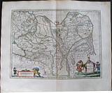 Tartaria sive Magni Chami Imperium. "Tartaria sive Magni Chami Imperium." Amsterdam Apud Johannem Guiljelmi F. Blaeu. c1655
Original coloured, copper engraved map of Tartary from volume 2 of Joan Blaeu's "Theatrum Orbis terrarum, sive atlas novus .pars secunda." Double page; folio; Latin text to verso.
Decorative title cartouche in the shape of a camel; strap work scale.
The map shows, North and North Eastern Asia: the Kingdom of Tartary, covering the area from the Caspian sea to the Pacific Ocean,O within the map references to mythical creatures and legends, like the devils and dragons in the Lop desert to the west of the Great Wall of China. Much of this information comes from the travel accounts of Marco Polo. Bright original outline colour; good impression; light damp stain to lower corners far from image.
Koeman1, Bl 24C. 380 by 495mm (15 by 19½ inches). €500
China and Japan.
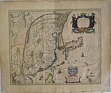 Chine & Japon. "China Veteribus Sinarum Regio nunc Incolis TAme dicta." Amsterdam: Johannes and Cornelius Blaeu. 1640 [but 1643-1645].
Copper engraved map of China with Japan from the 2nd edition of Blaeu's " Le Theatre du Monde ou Nouvel Atlas"Vol 2. Original outline colour; French text to verso.
'This edition ... is a much more advanced one than the edition of 1638/1640. The text has been reset' (Van der Krogt)
The map which is the first of Blaeu's maps of China has many mistakes and inaccuracies, for instance Korea is depicted as an island and Japan is lacking Hokkaido. In 1655 the map was replaced by the famous map of Father Martini, which corrected many of these inaccuracies.
Large decorative title cartouche and coat of arms with dedication to Theodore Bas, director of the V.O.C., many, apparently Dutch ships, to sea. Dark impression; evenly toned darker to edges; some scattered spotting, one darker large spot near dedicatory cartouche and another below in blank margin; centrefold split [approx. 120mm] at lower half with old repair to verso; paper fault to extreme lower right corner; light vertical crease to left side.
Van der Krogt II, p.150 and 2:212.2 ;Koeman:Bl 17: S [221]. 417 by 540mm (16½ by 21¼ inches). €1500
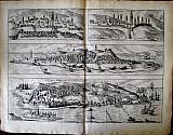
The Spice route:Portuguese Ports in Asia & Africa.
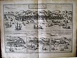 Frans Hogenberg & Simon Novellanus`
Calicut, Ormuz, Kannur & the fort of St George, Elmina in Ghana "Calechut Celeberimum Indiæ Emporium. ", "Ormus", "Canonor", & " S. Georgii opid Mina". Cologne Theodori Graminæi. 1572
Frans Hogenberg & Simon Novellanus`
Calicut, Ormuz, Kannur & the fort of St George, Elmina in Ghana "Calechut Celeberimum Indiæ Emporium. ", "Ormus", "Canonor", & " S. Georgii opid Mina". Cologne Theodori Graminæi. 15724 copper engraved views of Portuguese ports and trading cities in India and Africa from the first volume of Braun & Hogenberg's "Civitas Orbis Terrarum. " Latin text to verso. First state.
The views are of Calicut in South West India, Ormuz on the Straits of Hormuz, : Kannur in Kerala, India; and the Portuguese fort of St George at Mina, now Elmina in Ghana. Good impression; some staining staining. light extensive waterstain to upper view of calicut.
Keoman vol2; B&H1/54 330 by 473mm (13 by 18½ inches). Calicut:182x473mm; the other 3 views approx:143x155mm each. €450
Goa and Portuguese Trading Cities.
 Frans Hogenberg & Simon Novellanus`
Goa, Anfa- Casablanca, Azaamurum. & Dui. "Goa fortissima Indiæ urbs in Christianorum. ", "Dui", "Anfa. quibusdam Anaffa" & "Azaamurum" Cologne Theodori Graminæi. 1572
Frans Hogenberg & Simon Novellanus`
Goa, Anfa- Casablanca, Azaamurum. & Dui. "Goa fortissima Indiæ urbs in Christianorum. ", "Dui", "Anfa. quibusdam Anaffa" & "Azaamurum" Cologne Theodori Graminæi. 15724 copper engraved views of Portuguese ports and trading cities in India and Morocco from the first volume of Braun & Hogenberg's "Civitas Orbis Terrarum. " Latin text to verso. First state.
The views are of Goa and Dui in India; Anfa the historic centre of Casblanca & Azaamurum on the Atlantic coast of Morocco Good impression; a few light stains, mainly to blank margins.
Short tear at lower centrefold.
Keoman vol2; B&H1/57 337 by 467mm (13¼ by 18½ inches). Goa:130x467mm; Dui:90x467mm; Anfa: 90x227mm; Azaamurum: 90x225mm. €500
The Continent of Asia.
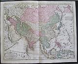 Asia Accurate in Imperia , Regna Staus & Populos Divisia, ad Usum Ludovici XV Galliarum Regis. Carte d'Asie.
Amsterdam. Covens et Mortier c1741
Copper engraved map of Asia from Covens & Mortier's " Nieuwe Atlas, Inhoudennde vier Gedeeltens der Waereld.. " Original full wash colour; verso blank.
Black and white strap work title cartouche [as issued].
The map after Guillaume De l'Isle's shows the whole continent, with part of Europe and Africa to the West across to the Pacific in the East.
Inset to upper right corner of Irkut.province. Dark impression; bright full wash colour; printed on heavy paper, short centre fold split at lower margin with old repair to verso and lower margin; old red crayon numbers to verso.
Koeman I: C&M 8:84, [C&M 10] 500 by 620mm (19¾ by 24½ inches). €650
Company: Bryan, Mary Louise.
Address: Ag. Andrianoy 92 , 21 100 Nafplio, Greece.
Vat No: EL 119092581