MAPS & VIEWS
PRINTS
BOOKS
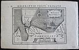
Miniature Map of the Straits of Vaigats, Vaygach - Nova Zembla Russia.
 Petrus Kaerius/Pieter van der Keere; Jodicus Hondius.
"Descriptio Freti Vaigats" Delineatio freti Vaigats. Amsterdam Jodicus Hondius Jr. 1616
Petrus Kaerius/Pieter van der Keere; Jodicus Hondius.
"Descriptio Freti Vaigats" Delineatio freti Vaigats. Amsterdam Jodicus Hondius Jr. 1616Copper engraved map of the Straits of Vaigats- Vaygach - Nova Zembla from Petrus Bertius' "Tabularum geographicum contractarum libri septum. " Latin text to verso describing the succeeding map.
The map shows the straits between Northern Russia and Vaygach island, part of the Nova Zembla archipelago.
Strap work title cartouche; compass rose, ship and whale to sea. Dark impression; light toning; upper right corner torn.
Koeman: Lan 11. 95 by 137mm (3¾ by 5½ inches). €50
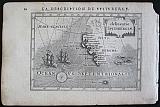
Miniature Map of Spitsbergen, Norway.
 Petrus Kaerius/Pieter van der Keere; Jodicus Hondius.
"Description de Spitsberge" delineatio Spitsberiæ. Amsterdam Jodicus Hondius Jr. 1616
Petrus Kaerius/Pieter van der Keere; Jodicus Hondius.
"Description de Spitsberge" delineatio Spitsberiæ. Amsterdam Jodicus Hondius Jr. 1616Copper engraved map of Spitsbergen, Norway from Petrus Bertius' "Tabularum geographicum contractarum libri septum. " French text to verso describing the succeeding map.
The map shows part of the coast of Spitsbergen. The island was discovered by by Willem Barentsz, who came across it while searching for the Northern Sea Route in June 1596 and it appears for the first time on his map of1599 as "Het Nieuwe Land"
Strap work title cartouche; compass rose, ships and fish to sea. Dark impression; light toning.
Koeman: Lan 11. 95 by 137mm (3¾ by 5½ inches). €120
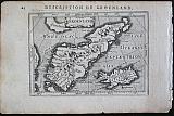
Miniature Map of Greenland.
 Petrus Kaerius/Pieter van der Keere; Jodicus Hondius.
"Description de Groenland" Groenland. Amsterdam Jodicus Hondius Jr. 1616
Petrus Kaerius/Pieter van der Keere; Jodicus Hondius.
"Description de Groenland" Groenland. Amsterdam Jodicus Hondius Jr. 1616Copper engraved map of Greenland from Petrus Bertius' "Tabularum geographicum contractarum libri septum. " French text to verso describing the succeeding map.
The map shows Greenland and Iceland.
Strap work title cartouche. Dark impression; light toning.
Koeman: Lan 11. 96 by 132mm (3¾ by 5¼ inches). €250
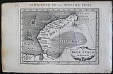
Miniature Map of Nova Zembla, Russia.
 Petrus Kaerius/Pieter van der Keere; Jodicus Hondius.
"Description de la Nova Zemle" Novæ Zemlæ delineatio. Amsterdam Jodicus Hondius Jr. 1616
Petrus Kaerius/Pieter van der Keere; Jodicus Hondius.
"Description de la Nova Zemle" Novæ Zemlæ delineatio. Amsterdam Jodicus Hondius Jr. 1616Copper engraved map of Novaya Zemlya from Petrus Bertius' "Tabularum geographicum contractarum libri septum. " French text to verso describing the succeeding map.
The map shows the Nova Zembla Archipelago the most Northern land mass in Europe. There are many details to the Northern outer coast, but little to the frozen inland coast, a ship lies icebound in the inner sea.
Novaya Zemlya consists of two major islands, separated by the narrow Matochkin Strait, and a number of smaller islands. The two main islands are Severny and Yuzhny . Novaya Zemlya separates the Barents Sea from the Kara Sea.
Strap work title cartouche; compass rose, ship and fish to sea. Dark impression; light toning
Koeman: Lan 11. 95 by 137mm (3¾ by 5½ inches). €80
Funen and the Danish Islands
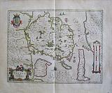 Isle de Fuynen Avec les Isles Dependant. "Fionia vulgo Funen." Amsterdam Apud Guiljelmum et Joahannem Blaeu. 1647
Original coloured, copper engraved map of Funen, Denmark from volume 1 of Joan Blaeu's "Le theatre du Monde ou Nouvel Atlas." Double page; folio; French text to verso.
Decorative title cartouche and coat of arms. Original colour; adhesion damage to surface atlower centrefold, in sea above ship; light creasing to left side; dark spot to lower right corner of blank margin.
Koeman1, Bl 16A [279(K)] 385 by 502mm (15¼ by 19¾ inches). €200
Denmark.
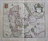 Danemark. "Dania Regnum." Amsterdam Apud Guiljelmum et Joahannem Blaeu. 1647
Original coloured, copper engraved map of Denmark from volume 1 of Joan Blaeu's "Le theatre du Monde ou Nouvel Atlas." Double page; folio; French text to verso.
Decorative title cartouche and coat of arms. Original colour; printers crease flattened causing loss of printed area close to centrefold [180 mm] up to "Z "of Zeeland. one dark spot to sea near at left; other tiny spots to Baltic sea; some soiling to blank margins.
Koeman1, Bl 16A [278(I)] 430 by 523mm (17 by 20½ inches). €300
Prussia
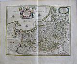 Prussia Accurata Descripta a Gasparo Henneberg erlichsi. "La Prusse" Amsterdam Apud Guiljelmum et Joahannem Blaeu. 1647
Original coloured, copper engraved map of Prussia from volume 1 of Joan Blaeu's "Le theatre du Monde ou Nouvel Atlas." Double page; folio; French text to verso.
Decorative title cartouche; ships to the sea. Original colour; lightly toned ; paint splodges to margins and below cartouche ; crease near centre fold and light spot.
Koeman1, Bl 16A [10(Bb)] 395 by 505mm (15½ by 20 inches). €450
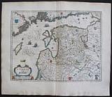
Northern Russia.
 Moscoviæ Pars Sept. & Orient "Russiæ, vulgo Moscovia dicta Partes Septentrionalis et Orientalis." Amsterdam Apud Johannem Guiljelmi F. Blaeu. c1645
Original coloured, copper engraved map of Northern & Eastern Russia from Joan Blaeu's "Theatrum Orbis terrarum, sive atlas novus ." Double page; folio; Latin text to verso.
Strap work cartouche & scale; coat of arms; ship to sea and animals to body of map.
The map shows the Northern part of Russia from Finland to just beyond the Jenisej River and south to the Volga River including the cities of Jaroslavl, Niznij Novgorod, and Kazan, with Tobolsk to the Northeast. Bright original outline colour; good impression; small dampstains to upper edge and larger dampstains to lower blank margin, far from image.
Koeman1, Bl 23A. 420 by 542mm (16½ by 21¼ inches). €450
Prussia.
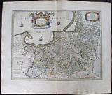 Prussia. "Prussia Accurata Descripta a Gasparo Henneberg Erlichsi. " Amsterdam Apud Guiljelmum et Joahannem Blaeu. 1647
Original coloured, copper engraved map of Prussia from volume 1 of Blaeu's "Theatrum Orbis terrarum, sive atlas novus ." Double page; folio; Latin text to verso.
Decorative title cartouche surmounted by coat of arms and flanked by allegorical figures ships to the sea. Original colour; light damp stain to edge of lower blank margin; short centre fold split at lower blank margin ..
Koeman1, Bl 23A. 395 by 505mm (15½ by 20 inches). €450
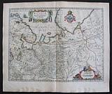
Livonia, the Baltic States of Latvia and Estonia.
 Livonia vulgo Lyfeland. "Livonia vulgo Lyfeland." Amsterdam Apud Johannem Guiljelmi F. Blaeu. c1645
Original coloured, copper engraved map of Livonia from Joan Blaeu's "Theatrum Orbis terrarum, sive atlas novus ." Double page; folio; Latin text to verso.
Decorative cartouche; ships to sea and shields with coats of arms to body of map.
The map shows the historical region of Livonia, present day Latvia and Estonia, on the Baltic Sea. Bright original outline colour; good impression dampstain to edges of lower blank margin, far from image.
Koeman1, Bl 23A. 387 by 506mm (15¼ by 20 inches). €500
Company: Bryan, Mary Louise.
Address: Ag. Andrianoy 92 , 21 100 Nafplio, Greece.
Vat No: EL 119092581