MAPS & VIEWS
PRINTS
BOOKS
Holland
 Hollandia. "Hollandia Comitatus. " Amsterdam Apud Guiljelmum et Joahannem Blaeu. 1647
Original coloured, copper engraved map of Holland from Blaeu's "Theatrum Orbis terrarum, sive atlas novus .Partis Prima pars Altera." Double page; folio; Latin text to verso.
Strap work title cartouche; scale on plinth with figure of geographer; coat of arms of lion rampant surrounded by wreath; empty cartouche to lower left corner surmounted by lion; inset map with decorative frame; ships and compass roses.
Blaeu's decorative map of Holland with an inset of the Dutch Islands of Texel, Vlielandt, etc. Original colour; light damp stain to edges of blank margins.
Koeman1, Bl 23A. 390 by 522mm (15¼ by 20½ inches). €1000
South Holland.
 Hollandia Australis, vulgo Zuyd-Holland. "Zuydhollandia stricte sumta." Amsterdam Apud Guiljelmum et Joahannem Blaeu. 1647
Original coloured, copper engraved map of South Holland from Blaeu's "Theatrum Orbis terrarum, sive atlas novus. Partis Prima pars Altera." Double page; folio; Latin text to verso.
Decorative title cartouche; ship and compass rose.
. Original colour; drop of wax[?] to left lower plate mark and rust spot and scattered small grey spotting to lower blank margin; light damp stain to upper edge of blank margin.
Koeman1, Bl 21A. 384 by 511mm (15 by 20 inches). €350
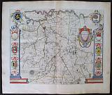
Central Holland.
 Rhenolandia. "Rhenolandiæ et Amstellandiæ exactisima Tabula. " Amsterdam Apud Guiljelmum et Joahannem Blaeu. 1647
Original coloured, copper engraved map of North Holland from Blaeu's "Theatrum Orbis terrarum, sive atlas novus. Partis Prima pars Altera." Double page; folio; Latin text to verso.
Decorative title cartouche; by coat of arms within wreath; Strapwork key to lower right corner; ships and compass roses.
The map shows Central Holland, Leyden, Haarlem, Amsterdam and Gouda. Original colour; light damp stain to edges of blank margins.
Koeman1, Bl 23A. 408 by 502mm (16 by 19¾ inches). €500
Overijssel.
 Transisalania, vulgo Over-Yssel. "Transisalania Dominium vernacule Over-Yssel. " Amsterdam Apud Guiljelmum et Joahannem Blaeu. 1647
Original coloured, copper engraved map of Overijssel from Blaeu's "Theatrum Orbis terrarum, sive atlas novus. Partis Prima pars Altera." Double page; folio; Latin text to verso.
Decorative title cartouche flanked by figures strap work explicatio cartouche, surmounted by coat of arms, anotherdecorative coat of arms and numerous small shields to body of map. Original colour; damp stains to blank margins, and also light cockling to upper right corner within plate.
Koeman1, Bl 23A. 415 by 520mm (16¼ by 20½ inches). €300
North Holland.
 West -Frisia sive Hollandia Borealis. "Hollandiæ pars Septenttrionalis vulgo Westvriesland en 'Tnoordier Quartier " Amsterdam Apud Guiljelmum et Joahannem Blaeu. 1647
Original coloured, copper engraved map of North Holland from Blaeu's "Theatrum Orbis terrarum, sive atlas novus. Partis Prima pars Altera." Double page; folio; Latin text to verso.
Title cartouche, surmounted by coat of arms and flanked by merpeople; ships and compass roses.
The map shows North Holland, Amsterdam and the polders. Original colour; light damp stain to edges of blank margins.
Koeman1, Bl 23A. 385 by 500mm (15¼ by 19¾ inches). €350
Decorative Map of Northern Brabant.
 Brabantia pars quarta;cujis caput Sylva-Ducis. "Quart Pars Brabantiæ cujus caput Silvaducis." Amsterdam Apud Guiljelmum et Joahannem Blaeu. 1647
Original coloured, copper engraved map of Northern Brabant from Blaeu's "Theatrum Orbis terrarum, sive atlas novus .Partis Prima pars Altera." Double page; folio; Latin text to verso.
Decorative title cartouche; two columns withmunicipal coats of arms to each side surmounted by putti; two large coats of arms of Brabant and 's-Hertogenbosch in each upper corner.
The map prepared by Willibrordus van der Burgt shows Northern Brabant with the capital 's-Hertogenbosch. Bright original colour; light damp stain to edge of lower blank margin; light spot to side blank margins, far from image.
Koeman1, Bl 23A. 412 by 526mm (16¼ by 20¾ inches). €550
Leige.
 Leodiensis Episcopatus " Leodiensis Diocesis." Amsterdam Apud Guiljelmum et Joahannem Blaeu. 1647
Original coloured, copper engraved map of the Diocese of Leige from Blaeu's "Theatrum Orbis terrarum, sive atlas novus .Partis Prima pars Altera." Double page; folio; Latin text to verso.
Decorative title cartouche surmounted by coats of arms and flanked by putti; strap work scale cartouche; compass rose. Bright original colour; damp stain upper and lower edges of blank margin, two creases to upper right corner.
Koeman1, Bl 23A. 378 by 497mm (15 by 19½ inches). €300
Duchy of Limburg.
 Limburgum Ducatus. "Ducatus Limburgem Auctore Ægidio Martini." Amsterdam Apud Guiljelmum et Joahannem Blaeu. 1647
Original coloured, copper engraved map of the Duchy of Limburg from Blaeu's "Theatrum Orbis terrarum, sive atlas novus .Partis Prima pars Altera." Double page; folio; Latin text to verso.
Large decorative title cartouche surmounted by putti; holding coat of arms.
The map prepared by Ægidio Martini shows the border area with the cities of Maestrict, Leige And Limburg.
The Duchy of Limburg or Limbourg was a state of the Holy Roman Empire. Its main territory, including the capital Limbourg,is today located within the Belgian province of Liège, with a small part in the neighbouring province of Belgian Limburg. Bright original colour; light damp stain to lower edge of blank margin; small brown spot at foot of centre fold, far from image.
Koeman1, Bl 23A. 382 by 505mm (15 by 20 inches). €400
Bird's eye View of Amsterdam.
 Amsterdam. Amsterdanum. Cologne G. von Kempen 1575
Black and white, copper engraved birds eye view of Amsterdam from the first volume of Braun & Hogenberg's Civitas Orbis Terrarum. French text to verso.
Very desirable and early town-plan of Amsterdam from a north-easterly direction. With a numbered key (1-28) in lower left corner.
On the left-hand side we can see how the mouth of the River Amstel has been dammed and its waters channeled into canals and made to pass through the city before flowing out into the Zuiderzee (today the IJsselmeer). The canals, which were used to transport imported goods to the counting houses located all over the city, are lined with private houses, commercial buildings and warehouses. In the center of the plan, the old town hall (Stadhuis, 21) and the neighboring Nieue Kerk (23) are also clearly recognizable. With its depiction of the heavy shipping traffic inside the harbour and on the Zuiderzee, the engraving conveys an impression of the contemporary scale of trade conducted in the continually expanding metropolis.
In the 13th century Amsterdam was simply a small fishing port built on marshy ground. In 1300 it was granted its municipal charter and in 1369 became a member of the Hansa. Not until the beginning of the 1600s did the city finally establish itself as the leading center of trade and the constantly expanding hub of a global financial and commercial empire.
This Golden Age brought not only an economic boom but also a flowering of the sciences and arts, which lasted until the end of the 17th century.
[Taschen, Braun and Hogenberg, p.78.] Dark impression; light toning and soiling; spo tbelow Title cartouche [ lighter to left side where it has been treansferrred] ; 4 spots to upper centre fold.; split at lower centrefold entering plate 1cm, with old repair to verso
Keoman 2; B&H 14, [plate 21]. 340 by 485mm (13½ by 19 inches). €1200
Brussels, Capital of Belgium.
 Brussels. Bruxelles. Paris. Thierry. Denys. 1683
Copper engraved view of Brussels from Mallet's "Description de l'Univers" 1st edition. Text to verso. Dark impression; light toning; slight soiling to blank margins.
150 by 101mm (6 by 4 inches). €80
Company: Bryan, Mary Louise.
Address: Ag. Andrianoy 92 , 21 100 Nafplio, Greece.
Vat No: EL 119092581