MAPS & VIEWS
PRINTS
BOOKS
Guinea, West Africa.
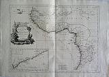 Guinea with the Capo Verde iislands, Senegal, the coast of Guinea itself and the Kingdoms of Loango, Congo, Angola and Benguela. " Carte de la Guinée contenant les Isles du Cap Verd, le Senegal, la Côte de Guinée proprement dite, les Royaumes de Loango, CongoAngola et Benguela...." Venice, Remondini, 1779
Copper engraved map of West Africa from Santini's "Atlas universel dressé sur les meilleures cartes modernes". Original outline colour; verso blank.
The map after Bonne shows the coastal regions of West Africa, with an inset map of the Gold coast after d'Anville.
Black & white decorative title cartouche with a lion or leopard and large crocodile. Dark impression; some light staining to blank margins.
460 by 625mm (18 by 24½ inches). €200
Scapula Lexicon.
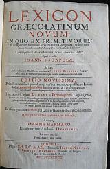 Lexicon GræcoLatinum Novum. Lexicon Græco-Latinum novum : in quo ex primitivorum & simplicium fontibus derivata atque composita (ordine non minùs naturali, quàm alphabetico,) breviter & dilucidè deducuntur. Cui appendix est exactissimus Græci idiomatis index oper & studio Ioannis Scapulæ. Ad hæc, auctarium extat dialectorum omnium à Iacobo Zvingero Phil. & Med. Basil. in expeditas succinctâsque tabulas compendiosè redactarum. Editio novissima, prioribus omnibus quibuscun[que] auctior, annexo copiosissimo Latino indice Laurentij Martij Palatini ... Huc accessit etiam lexicon etymologicum linguæ Græcæ ... Autore, Ioanne Harmaro ex celeberrima Academia Oxoniensi Londini London Typis T(homæ )H(arperi), T(homas )C(otes), and A(nne )G(riffin,) impensis Iocosæ Norton. & Richardi Whitakeri. Prostant ad Insignia Regia, in Cœmeterio D. Pauli, st. 1637.
Folio; 4 parts in 1:[12] p., 1856 columns, [187] p., 7-190 columns, [241] p.; [4] p., 64 columns;
Title page in red and black; the roman numeral date is made with turned C's. titles to each part with colophons.
Index Latinus (unpaginated, , ²A-²V) has separate dated title page with excudebat Tho. Cotes in imprint. Lexicon etymologicum linguae Graecae has separate register and dated title page with typis Annae Griffin in imprint.
Cotes and Griffin also pr[inted]. sections of pt.1
The colophon to Appendixis dated 1636 Apud Richardum Whittakerum
Later [19th century?] diced calf ; six raised bands gilt; marbled end papers,
The volume includes
Part!:Lexicon Græco-Latinum novum in 1856 columns, plus index;
Part 2 : Iacobi Zvingeri ... Græcarum dialectorum Hypotyposis& Apendixeorum Quae Insipso Lexico Commode;
Part 3: Index Latinos in Iohannis Scapulæ Lexicon Græco latinum.... Laurenti Martii Palatini;
Part 4:Lexicon Etymologicum Linguæ Græcæ ... Ioanne Harmaro
Joints with light rubbing; spotting to blank side of end papers; internally generally clean and crisp. rear inner joint starting.
Part 2; Appendix: ß1 & ß2 stuck together at inner gutter; ß5page loose, never stitched in.
Part 3 Index Latinus: tear to margin of G4 just touching textwith loss to blank margin but not text.
1 Clark's Bibliog. Dict. vol. IV.*-Balllet Jugemens.Morhoff Poly hist.;George Lillie Craik.The Pursuit of Knowledge Under Difficulties, Volume 8 page 161-3. 350 by 235mm (13¾ by 9¼ inches). €850
The North Pole.
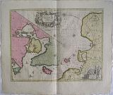 The North Pole and the adjacent Arctic lands Newly and Accurately Described. "Novi et Acurata Poli Arctici et terrarum Circum Iacentium Descriptio." Amsterdam Schenk, Petri & Valk Gerardi c1700
Copper engraved map of the Arctic, the North Pole and adjacent lands from Schenk And Valk's " Atlas Contractus." Original full wash colour; verso blank
The map from the plate by Janssonius was originally published in 1637, eventually replaced Hondius' map of the North Pole and became the prototype for many later maps including those of Blaeu.
Rhumb lines radiate from the North Pole and several compass roses and ships embellish the chart. A large title cartouche, with two figures and numerous wind heads, conveniently hides the northwest coast of America. Small cartouche depicting men, a polar bear and foxes at lower right with the imprint of Schenk and Valk.
Fifth state of the plate with Nova Zembla connected to the mainland with a land bridge and the completed coastline of Spitzbergen . Good impression with bright colour; generally clean; a few spots to blank margins; short centre old split at lower margin [approx 20mm backed with archival tape].
The maps of Schenk and Valk are famous for their full wash colour , however often the pigments, particularly in the greens deteriorated leading to browning and eventually could cause the paper to crack, for this reason it is unusual to see such bright original colour.
Koeman III,page 115 Sche 2/ Val1. 410 by 518mm (16¼ by 20½ inches). €1000
Perche & Blasois, France.
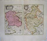 The County of Blaisois. The County of Perche. "Comitatus Blesensis, Auctore Joanne Temporio. Blaisois." & " Perchensis Comitatus. La Perche Comte". Amsterdam Schenk, Petri & Valk Gerardi c1700
Copper engraved maps, 2 on 1 plate of of the region of Blaisois and Perche in France from Schenk And Valk's " Atlas Contractus." Original full wash colour; verso blank.
The map shows the region of Blaisois with the capital Blois on the Loire in the Loir-et-Cher department and Perche former province of western France extending over the départements of Orne, Eure, Eure-et-Loir and Sarthe,from which many emigrated to Canada in the 17th century leading to most French Canadians being able to trace their ancestry back to this region,
Each map with decorative title cartouche. Dark impression; clean and bright; green lines slightly oxidised/browned, small cracking near centre of centrefold. along the Loire on map of Blaisois; 1 wormhole to map of Blaisois, by town of St Laurent with another in the blank margin above; 2 old ink numbers to upper right corner, and one to verso.
Koeman III,page 113, map 280. 402 by 510mm (15¾ by 20 inches) full plate. €200
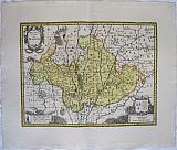
Beauce, France.
 The Region of Beauce "Belsia Vulgo La Beausse." Amsterdam Schenk, Petri & Valk Gerardi c1700
Copper engraved map of the region of Beauce in France from Schenk And Valk's " Atlas Contractus." Original full wash colour; verso blank.
The map shows the agricultural region of Beauce with the capital Chartres.
Decorative title cartouche, with Ceres harvesting grain and a cart drawn by dragons; coat of arms upper right with scale. Dark impression; clean and bright; old ink number to verso.
The maps of Schenk and Valk are famous for their full wash colour , however often the pigments, particularly in the greens deteriorated leading to browning and eventually could cause the paper to crack, for this reason it is unusual to see such bright original colour.
Koeman III,page 113, map 281. 384 by 496mm (15 by 19½ inches). €250
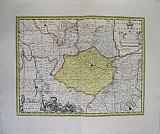
Blaisois, France.
 The Region of Blois, Blaisois. "Description du Blaisois." Amsterdam Schenk, Petri & Valk Gerardi c1700
Copper engraved map of the region of Blaisois in France from Schenk And Valk's " Atlas Contractus." Original full wash colour; verso blank.
The map shows the region of Blaisois with the capital Blois on the Loire in the Loir-et-Cher department.
Decorative title cartouche, scale and coat of arms. Dark impression; clean and bright; old ink number to verso.
The maps of Schenk and Valk are famous for their full wash colour , however often the pigments, particularly in the greens deteriorated leading to browning and eventually could cause the paper to crack, for this reason it is unusual to see such bright original colour.
Koeman III,page 113, map 282? 372 by 485mm (14¾ by 19 inches). €200
Æthiopia, Abyssinia, the Kingdom of Prester John.
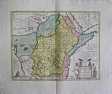 Æthiopia, Superior and Inferior commonly called Abyssinia or the Kingdom of Prester John. "Aethiopia Superior vel Interior vulgo Abissinorum sive Prebiteri Joannis Imperium." Amsterdam Schenk, Petri & Valk Gerardi c1700
Copper engraved map of East Africa Æthiopia from Schenk and Valk's " Atlas Contractus." Original full wash colour; verso blank.
The map shows a major section of central and eastern Africa including Mozambique north to present day Sudan
The map contains numerous coastal place names such as Mozambique Island, Quiloa, Mombaza, and Melinde indicating the importance of the area to both Arab, Portuguese, and traders and explorers from other countries. Congo is shown on the west coast and the two lakes of Zaire and Zaflan described by Ptolomy are in the lower portion of the map. Lake Niger, and the supposed course of the Niger River, is shown flowing westward. This map is based on Ortelius' map of Prester John of 1573.
Decorative title cartouche, black and white as issued; elephants, ostriches and monkeys within the land.
The legends of Prester John (also Presbyter Johannes) were popular in Europe from the 12th through the 17th centuries, and told of a Christian patriarch and king said to rule over a Christian nation lost amidst the Muslims and pagans in the Orient. Written accounts of this kingdom are variegated collections of medieval popular fantasy. Prester John was reportedly a descendant of one of the Three Magi, said to be a generous ruler and a virtuous man, presiding over a realm full of riches and strange creatures, in which the Patriarch of the Saint Thomas Christians resided. His kingdom contained such marvels as the Gates of Alexander and the Fountain of Youth, and even bordered the Earthly Paradise. Among his treasures was a mirror through which every province could be seen, the fabled original from which the "speculum literature" of the late Middle Ages and Renaissance was derived, in which the prince's realms were surveyed and his duties laid out.
At first, Prester John was imagined to reside in India; tales of the Nestorian Christians' evangelistic success there and of Thomas the Apostle's subcontinental travels as documented in works like the Acts of Thomas probably provided the first seeds of the legend. After the coming of the Mongols to the Western world, accounts placed the king in Central Asia, and eventually Portuguese explorers convinced themselves that they had found him in Ethiopia, which had been officially Christian since the 4th century. Prester John's kingdom was thus the object of a quest, firing the imaginations of generations of adventurers, but remaining out of reach. He was a symbol to European Christians of the Church's universality, transcending culture and geography to encompass all humanity, in a time when ethnic and inter-religious tension made such a vision seem distant. Good impression with bright colour.
The maps of Schenk and Valk are famous for their full wash colour , however often the pigments, particularly in the greens deteriorated leading to browning and eventually could cause the paper to crack, for this reason it is unusual to see such bright original colour.
Koeman III, page 114 Map 447; Sche 2/ Val1. 380 by 514mm (15 by 20¼ inches). €600
Guinea, West Africa.
 Guinea. "Guinea." Amsterdam Schenk, Petri & Valk Gerardi c1700
Copper engraved map of Guinea, West Africa after Janssonius from Schenk and Valk's " Atlas Contractus." Original full wash colour; verso blank.
The map after Jansonnius shows the coast of West Africa from Sierra Leone to Gabon, focused upon Guinea and Benin; numerous elephants, lions and monkeys within the land; ships, monsters and compass roses to sea.
Decorative title cartouche surmounted by natives and monkeys; 2 black putti bear an elephant tusk above the sea at bottom left corner. Good impression with bright colour; worm track to upper centre fold in blank margin with old paper repair to verso, not entering image.
The maps of Schenk and Valk are famous for their full wash colour , however often the pigments, particularly in the greens deteriorated leading to browning and eventually could cause the paper to crack, for this reason it is unusual to see such bright original colour.
Koeman III, page 114 Map 446; Sche 2/ Val1. 380 by 514mm (15 by 20¼ inches). €500
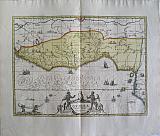
North Africa and the Barbary coast.
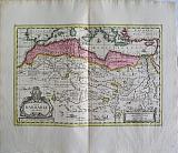 New Barbary described. "Nova bARBARIæ DESCRIPTIO." Amsterdam Schenk, Petri & Valk Gerardi c1700
Copper engraved map of North Africa from Schenk and Valk's " Atlas Contractus." Original full wash colour to Barbary, otherwise outline colour; verso blank.
The map shows the coast of North Africa and most of the Mediterranean sea with cities in Spain and Portugal particularly marked. Along the coast are the various North African kingdoms. Fez Tunis etc, which make up "Barbary" The course of the Nile is shown with much detail as are the other rivers. Numerous texts give information, The whole land is decorated with wild animals; elephants, antelopes, lions, leoprds, camels, ostriches, monkeys, crocodiles and even dragons.
Decorative title cartouche, black and white as issued. Good impression with bright colour.
The maps of Schenk and Valk are famous for their full wash colour , however often the pigments, particularly in the greens deteriorated leading to browning and eventually could cause the paper to crack, for this reason it is unusual to see such bright original colour.
Koeman III, page 114 Map 407; Sche 2/ Val1. 352 by 513mm (13¾ by 20¼ inches). €350
Scarce Small Map of Corfu.
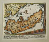 The Island of Corfu.... Kerkyra. "Het Eilant Corfu.... Corcyra...." Amsterdam Schenk, Petri 1716=1720
Copper engraved map of Corfu/Kerkyra by Petrus Schenk. Modern hand colour; verso blank.
Scarce small map of the island of Corfu, taken from a larger map sheet , probably from "Schouwburg van den oorlog, beginnende van Koning Karel den II, tot op Koning Karel den III Theatrum bellicum, incipiens a Carolo II. Hispaniarum Rege ad Carolum III. Amsterdam: Pieter Schenk."[1714-1720]
The map is drawn upon a drape or wall hanging with fringe; it shows the island lying off the coast , with the large bay of Butrinto . the text below in Dutch and French discusses the events of July 8th 1716. known as
The Siege of Corfu;after their success in the Morea, the Ottomans moved against the Venetian-held Ionian Islands. They had occupied the island of Lefkada (Santa Maura), which the Venetians had taken in 1684, and the fort of Butrinto opposite Corfu. On 8 July 1716, an Ottoman army of 33,000 men landed on Corfu, the most important of the Ionian islands. Despite an indecisive naval battle on the same day, the Ottoman land army continued its disembarkment and advanced towards the city of Corfu. On 19 July, after capturing the outlying forts of Mantouki, Garitsa, Avrami and of the Saviour, the siege began.[The defence was led by Count Johann Matthias von der Schulenburg, who had roughly 8,000 men at his command. The extensive fortifications and the determination of the defenders withstood several assaults. After a great storm on 9 August—which the defenders attributed to the intervention of Corfu's patron saint, Saint Spyridon—caused significant casualties among the besiegers, the siege was broken off on 11 August and the last Ottoman forces withdrew on 20 August. Good impression. good margins to left and bottom but short top and right as it has obvoiusly been cut from a larger sheet.
Zacharakis; 3275/2139;Koeman III, page 116 Sche 7 160 by 180mm (6¼ by 7 inches). Pagesize;200x280mm. €500
Company: Bryan, Mary Louise.
Address: Ag. Andrianoy 92 , 21 100 Nafplio, Greece.
Vat No: EL 119092581