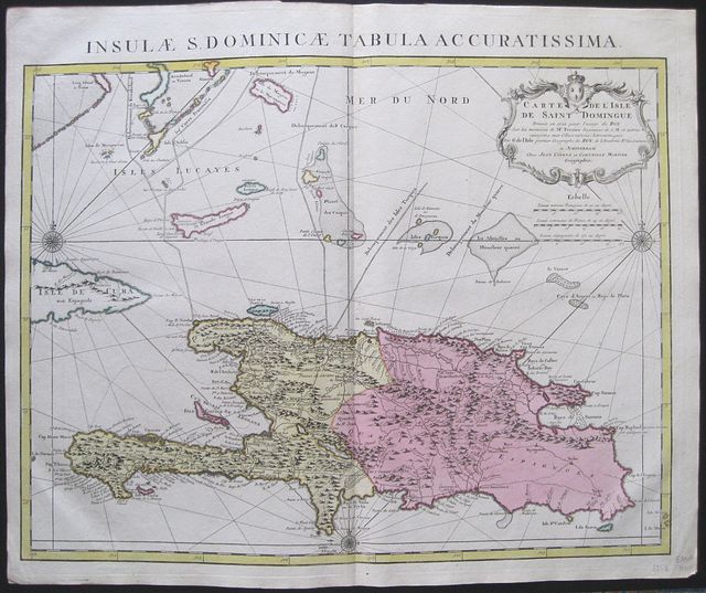
Saint Domingo, Hispaniola.
Covens, Jean & Mortier, Corneille.
Insulæ S, Dominicæ Tabula Accuraetissima. Carte de l'Isle de Saint Domingue Dressee en 1722 pour l'usage du Roy sur les memoires de Mr. Frezier Ingenieur de S.M. et autres assujettis aux Observations Astronomiques ..
Amsterdam. Covens et Mortier Dated 1722 to cartouche but c1741
Copper engraved map or chart of of the island of Hispaniola showing St. Domingo from Covens & Mortier's "
Nieuwe Atlas, Inhoudennde vier Gedeeltens der Waereld.. " Original full wash colour; verso blank.
Black and white strap work title cartouche [as issued].
The map after Guillaume De l'Isle shows the whole island in detail; the Western half [ now Haiti was ] taken by the French in 1659, whilst the Eastern half remained Hispaniola under the control of the Spanish, [ now the Dominican Republic].
Saint-Domingue was a French colony on the Caribbean island of Hispaniola from 1659 to 1804. The French mainly Buccaneers had established themselves on the western portion of the islands of Hispaniola and Tortuga by 1659. In the Treaty of Ryswick of 1697, Spain formally recognized French control of Tortuga island and the western third of the island of Hispaniola.
The map also shows the Eastern tip of Cuba and the nearby islands; with borders indicated between. 2 compass roses and rhumb lines have been added making it more of a sea chart. Dark impression; bright full wash colour; printed on heavy paper; old red crayon numbers to verso.
Covens & Mortier
as a firm existed between 1721-1778, taking over the business of Pierrre Mortier.
Johannes / Jean Covens and Cornelius Mortier were brothers- in- law following the former's marriage to Mortier's sister Agatha in 1721, when they also formally went in to partnership.
Under the Covens and Mortier imprint, Cornelius and Jean republished the works of the great 17th and early 18th century Dutch and French cartographers De L'Isle, Allard, Jansson, & De Wit. The firm would become one of the most prolific Dutch publishing concerns of the 18th century.
The company would pass down through the Covens family as Mortier had no children, changing the name to Covens & Zoon until Pieter Mortier IV a great grandson of the original founder joined the firm and saw the name restored to Mortier Covens & Zoon. ( See Koeman I p45).
Guillaume de l'Isle (1675-1726)
was the son of a cartographer and pupil of Jean Dominique Cassini, who, among other important contributions, aligned the study of astronomy to the study of geography. Under Cassini's direction, observations were made from locations all over the world that enabled longitudinal calculations to be made with much greater accuracy. De l'Isle carried on this exacting work with remarkable dedication and integrity, constantly revising and improving his maps. While precision was his primary goal, his maps are invariably elegant and attractive.
The French cartographer Guillaume de l'Isle (1675−1726) was admitted into the French Académie Royale des Sciences when he was 27 years old and subsequently became the first person to receive the title Premier Géographe du Roi (principal geographer to the king). At the time de l'Isle was engaged in cartographic research, the prestige of a cartographer and the authority of his maps were gauged by the veracity of the cartographer's sources, i.e., the explorers and travelers who reported details of their travels to geographers and cartographers in Europe.
Many of de l'Isle's maps were reissued by the publishing house of Cornelis Mortier and Johannes Coven in Amsterdam in their Atlas Nouveau, which was published in multiple editions, the earliest of which dates to 1730.
Koeman I: C&M 8:116. 515 by 627mm (20¼ by 24¾ inches).
ref: 3058
€600