MAPS & VIEWS
PRINTS
BOOKS
back to search results place the mouse over an image to zoom
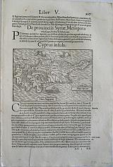
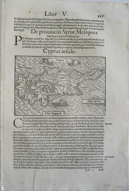
Cyprus.
"Cyprus" "Cyprus Insula." Basileae Henricum Petri 1552.Vignette woodcut map of Cyprus from Sebastian Münster's famous "Cosmographia". Black and white; set in a page of text; Latin text and further vignette to verso.
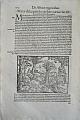
The map which first appeared in the 1550 Latin edition, shows the island with a banner title and ship to sea. Set in a page of text about the island on the verso of the map is a woodcut vignette depicting 2 deer as the text quotes Pliny " Stags cross the sea in herds, swimming in a long line, the head of each resting on the haunches of the one that precedes it, each in its turn falling back to the rear. This has been particularly remarked when they pass over from Cilicia to the island of Cyprus. Though they do not see the land, they still are able to direct themselves by the smell. "Pliny the Elder: Natural History Book 8 ch 32. Good impression; long tear from bottom edge through text just entering image by 15mm through " Mare Aegyptiu"to keel of ship [Repaired to verso with archival tape].
Sebastian Münster 1488- 1552
was a German cartographer, cosmographer, and a Christian Hebraist scholar. His work, the Cosmographia from 1544, was the earliest German description of the world.
It had numerous editions in different languages including Latin, French, Italian, English, and even Czech. The Cosmographiawas one of the most successful and popular works of the 16th century. It passed through 24 editions in 100 years. This success was due to the fascinating woodcuts (some by Hans Holbein the Younger, Urs Graf, Hans Rudolph Manuel Deutsch, and David Kandel), in addition to including the first to introduce "separate maps for each of the four continents known then-America, Africa, Asia and Europe." It was most important in reviving geography in 16th century Europe. The last German edition was published in 1628, long after his death.
During the 1530s and 1540s, most map production in Europe was coming from Basel, Venice, Paris, Zurich and Louvain, and Münster has been described as one of the principal players in the development of German geography and cartography. In 1540 he published an edition of Claudius Ptolemy's Geographia that included the standard 27 Ptolemaic maps augmented by 21 modern maps of his own creation including this map of the New World. The Geographia was reprinted in 1542, 1545, and 1552, all in Latin. Map scholar Ralph Ehrenberg said that "Münster's revision of Ptolemy's Geography is considered the culmination of Ptolemaic revisions." In 1544 Münster published his Cosmographia in Latin that included the map of the New World and many others. The Cosmographia was "one of the great publishing successes of the sixteenth century." One historian has stated that it was republished in five languages in forty six editions, the last in 1650. Map scholar Peter Meurer relays that that Münster's cosmography was accessible to those Czechs, Germans, French, and Italians who could read their vernacular languages. With this significant audience and maps that were relatively easy to read, he had a huge impact on the way large numbers of people were coming to imagine the world. In 1550 the Cosmographia was extensively updated with woodcuts of 68 maps and 910 town views, people, places and animals based on contributions from over 120 persons. The map featured here is from the 1550 Latin edition of the Cosmographia.
The explanation for the popularity of Mönster's Cosmographia involves recognition of the historical roots of the science of cosmography and its complex evolution in the sixteenth century as scholars attempted to incorporate the flood of new observational knowledge with classic modes of ordering the universe. The sources of new knowledge were diverse. In the year preceding the publication of Münster's Cosmographia (1543), the classic Aristotelian concept of the cosmos was challenged by Nicolaus Copernicus who "reordered the planetary spheres" in his De revolutionibus orbium coelestium by advancing the heliocentric theory of the universe. In that same year Andreas Vesalius published one of the most influential and groundbreaking books on human anatomy. Several European nation states were actively engaged in maritime exploration. Expansion of Spanish dominion in the Americas was rapid during this time. Historian Henry Wagner has noted that by about 1540, "Spanish discovery in the New World was largely complete." Increasing textual information on geographical discoveries and first encounters with native peoples demanded accompanying visual images. Münster's map of the New World provided an interpretation of the geography and topography described in textual accounts and a few prior maps. As with all maps throughout history, it was an abstraction of the represented territory, and it is of value to try to explicate each element of the map. However, in my opinion, the most important observation to make about the map was its truly remarkable role in creating geographical and geopolitical identity. As Ralph Ehrenberg has said, "Most Renaissance Europeans first viewed their world and new discoveries in America…through the eyes of the…German humanist Sebastian Münster and his major illustrated books, Geographia Universalis and Cosmographia Universalis."["Tabula nouarum insularum," by Sebastian Münster, 1538 [1550]. Analysis by Dr. James Walker.]
Zacharakis :2447/1586 98 by 150mm (3¾ by 6 inches). Full page:318x210mm.. ref: 2810 €300
Company: Bryan, Mary Louise.
Address: Ag. Andrianoy 92 , 21 100 Nafplio, Greece.
Vat No: EL 119092581