MAPS & VIEWS
PRINTS
BOOKS
back to search results place the mouse over an image to zoom
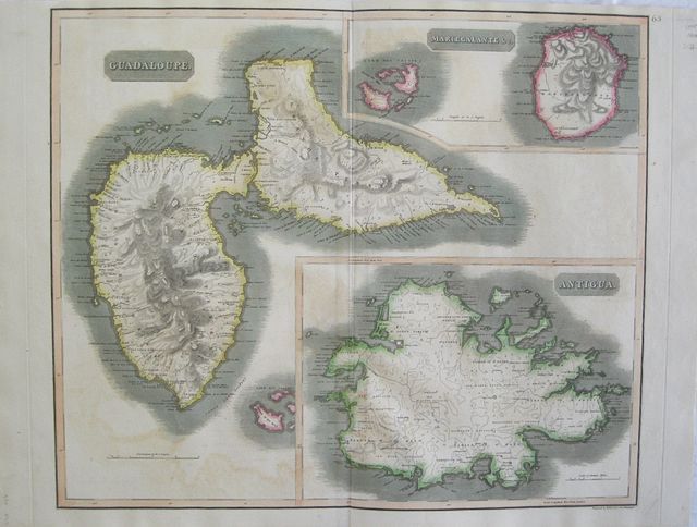
Islands of the West Indies: Guadaloupe, Antigua and Marie-Galante.
John Thomson Guadaloupe, Antigua and Marie-Galante. "Guadaloupe; Mariegalante &c and Antigua." Edinburgh, London & Dublin John Thomson;Baldwin, Cradock, and Joy; John Cumming. 1817Copper engraved map showing Guadaloupe, Antigua and Marie-Galante from Thomson's "A New General Atlas." Original outline colour; verso blank.
The large map is dominated by Guadaloupe with Marie-Galante to the top right and Antigua below, the format no doubt caused by the shape of Guadaloupe.
The map served as the source for Fielding Lucas. Good impression, generally clean & bright; slight very light offsetting; tiny paper faults to left blank margin,and slight thinning in the image of Guadaloupe; without upper general title in margin; old ink number to upper right corner.
John Thomson (1777-c1840),
was a Scottish cartographer from Edinburgh, celebrated for his 1817 New General Atlas, published by himself in Edinburgh, John Cumming in Dublin, and Baldwin, Cradock, and Joy in London.
The title page described it as:
"A new general atlas, consisting of a series of geographical designs, on various projections, exhibiting the form and component parts of the globe; and a collection of maps and charts, delineating the natural and political divisions of the empires, kingdoms, and states in the World. Constructed from the best systematic works, and the most authentic voyages and travels. With a memoir of the progress of geography, a summary of physical geography, and a consulting index to facilitate the finding out of places. Edinburgh: Printed by George Ramsay and Company, for John Thomson and Company, Edinburgh; Baldwin, Cradock, and Joy, London; and John Cumming, Dublin. 1817."
The atlas was probably inspired in part by Pinkerton's Modern Atlas of 1815, which it resembles. Pinkerton began publishing his atlas maps in parts as early as 1809, while Thomson started in 1814. Thomson used engravers of Edinburgh, including Kirkwood, Menzies, and Moffat, as well as the London engravers Hewitt and Neele (Neele also engraved all the maps for Pinkerton's Modern Atlas).
Thomson adds about twenty maps not found in Pinkerton, eight of which are of islands in the West Indies that served as the source for Fielding Lucas' maps of those islands.
[David Rumsey Map Collection Catalogue/Cartography Associates.]
540 by 650mm (21¼ by 25½ inches). ref: 2562 €300
Company: Bryan, Mary Louise.
Address: Ag. Andrianoy 92 , 21 100 Nafplio, Greece.
Vat No: EL 119092581

