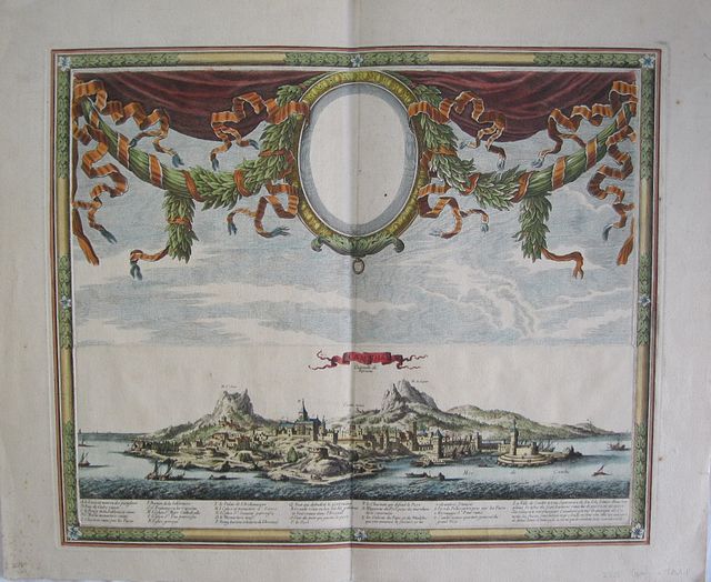
Scarce Ornamental View of Iraklion.
Beaulieu, Sebastian de Pointault, Chavalier de
Candia, Capital of the Kingdom "
Candie, Capitalle du Royaume." Paris chez l'Autheur. without date. [1667-1694].
Copper engraved panaoramic view of Iraklion from "
Les Glorieuses Conquetes de Louis de Grand.." Modern colour; verso blank.
The impressive view of Iraklion is surrounded by a decorative faux frame. Printed from two copper plates the upper half has an ornate garland with swags of leaves suspending an empty locket/frame [a portrait of Louis XIV was intended to be within the frame with his coat of arms suspended below from the small brass ring].
In the lower half a view of Iraklion from the sea with a key below to important edifices within the city. Good Impression, printed on thick laid paper; minor spotting, mainly to blank margins, a couple within the image; two short tears to right edge. {repaired with archival tape to verso].
Chevalier de Beaulieu (1612? -1674) Sébastien Beaulieu of Pontault (c. 1612 - 1674 ),
Mr. Beaulieu le Donjon and Knight of the Order of St. Michael, known as the Knight of Beaulieu,
was Field Marshal and military engineer in the service of Louis XIV of France .
He published the "Little Beaulieu" (series of maps and profiles) and the first plates of "
Les Glorieuses Conquêtes de Louis le Grand, Roy de France et de Navarre, ou sont representées les cartes, profils, plans des villes avec leurs attaques, combats, batailles et victoires, prises, et remportées sur ses ennemis, tant par mer que par terre, ", 2 vol. 4 volumes fol., Paris, chez the Autheur, nd [1667-1694]. Known in successive editions as the Grand Beaulieu,
it is a huge collection of maps and plans of sieges, battles and expeditions reign of Louis XIV of France from the Battle of Rocroi to making Namur ( 1,643th - 1,692 ) .
Beaulieu, with the help of different writers, produced and published the plates in 1646 . Unfinished at his death it was continued by his niece, Reine des Roches Beaulieu, and her husband with other partners concluding the work in 1694.
It includes valuable material on the Reapers' War and on the Nine Years War in Catalonia .
The maps and plans of fortifications and terrain of the battlefields that he drew and recorded have led to Beaulieu being considered one of the creators of military topography.
see Zacharakis:246/135, for details of the map from the same work. 459 by 560mm (18 by 22 inches).
ref: 2525
€1100