MAPS & VIEWS
PRINTS
BOOKS
The Americas.
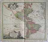 America North and South Newly represented... "Totius Americae Septrionalis et Meridionalis Novissima Representatio quam ex singulis Geographorum Tabulis collecta luci publicae accommodavit .." Nuremberg Homann, Johann Baptist c1720
Copper engraved map of the continent of America by Johann Bapt. Homann from his "Grosser Atlas". Original colour, verso blank.
Decorative title cartouche and vignette showing native Americans and the fauna and flora of the country, with another cartouche surrounding a description of discoveries, black and white as issued. The title cartouche is based upon De Fer's landmark map of 1699. The top cartouche is based upon De L'Isle's 1703 map of Canada. The map is a revision of the elder Homann's 1710 map of the Americas. After his death in 1724, his son (Johann Christoph Homann) re-engraved the plate to correct the western coastline of North America, shown here extending very far west and north, with very little detail. California is no longer shown as an island, although the remnants of the interior sea can be seen near the Pais de Moozemleck, and a hint of a hoped for Northwest Passage is beginning to take shape. The Great Lakes are taking shape, being actively explored by the French fur traders and Hudson Bay Company. Good dark impression, generally bright and clean; slight soiling to lower corners; short centrefold split at lower margin [40m just entering scale lines with old tape repair to verso]; slight unobtrusive vertical crease to right of centrefold.
490 by 583mm (19¼ by 23 inches). €1600
The Americas.
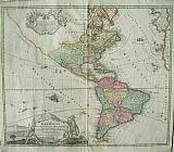 America "Totius Americae Septrionalis et Meridionalis Novissima Representatio quam ex singulis Geographorum Tabulis collecta luci publicae accommodavit .." Nuremberg Homann, Johann Baptist c1720
Copper engraved map of the continent of America by Johann Bapt. Homann from his "Grosser Atlas" . Original colour, verso blank.
Decorative title cartouche and vignette showing native Americans and the fauna and flora of the country,with another cartouche surrounding description of discoveries, black and white as issued. The title cartouche is based upon De Fer's landmark map of 1699. The top cartouche is based upon De L'Isle's 1703 map of Canada. The map is a revision of the elder Homann's 1710 map of the Americas. After his death in 1724, his son (Johann Christoph Homann) re-engraved the plate to correct the western coastline of North America, shown here extending very far west and north, with very little detail. California is no longer shown as an island, although the remnants of the interior sea can be seen near the Pais de Moozemleck, and a hint of a hoped for Northwest Passage is beginning to take shape. The Great Lakes are taking shape, being actively explored by the French fur traders and Hudson Bay Company. Good impression; old rust marks to upper margin (from a paperclip) just entering scale; small hole to left of these in blank margin; small rust spot east of the Solomon islands.
490 by 583mm (19¼ by 23 inches). €1300
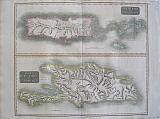
Islands of the West Indies: Jamaica.
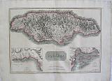 Jamaica with insets of Bluefields, and Kingston. "Jamaica; The Harbour of Bluefields; The Harbours Of Kingston and Port Royal." Edinburgh, London & Dublin John Thomson;Baldwin, Cradock, and Joy; John Cumming. 1817
Copper engraved map of Jamaica from Thomson's "A New General Atlas." Original outline colour; verso blank.
The large plate shows the island of Jamaica with inset maps, details of the bay of Bluefields in Westmoreland Parish and the harbour of Kingston showing the position of Port Royal on the Palisadoes.
The map served as the source for Fielding Lucas. Good impression; 3 tiny holes /paper faults to left blank margin; very small stain near scale, [a squashed bug?] ; old ink number to upper right corner.
444 by 680mm (17½ by 26¾ inches). €400
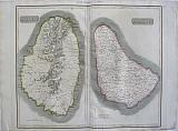
Islands of the West Indies: Martinique and Dominica.
 Martinique; the bay at Fort Royal and Dominica. "Martinico; Dominica; Cul de Sac Royal." Edinburgh, London & Dublin John Thomson;Baldwin, Cradock, and Joy; John Cumming. 1817
Copper engraved map showing Martinique and Dominica from Thomson's "A New General Atlas." Original outline colour; verso blank.
The large map shows the two islands engraved on one plate. The map of Martinique includes an inset map of the bay at Fort Royal.
The map served as the source for Fielding Lucas.
In 1635, Pierre Belain d'Esnambuc, French governor of the island of St. Kitts, landed in the harbour of St. Pierre with 150 French settlers after being driven off St. Kitts by the English. D'Esnambuc claimed Martinique for the French King Louis XIII and the French "Compagnie des Îles de l'Amérique" (Company of the American Islands), and established the first European settlement at Fort Saint-Pierre (now St. Pierre).
In 1636, the indigenous Caribs rose against the settlers to drive them off the island in the first of many skirmishes. The French successfully repelled the natives and forced them to retreat to the eastern part of the island, on the Caravelle Peninsula in the region then known as the Capesterre. When the Carib revolted against French rule in 1658, the Governor Charles Houel de Petit-Pré retaliated with war against them. Many were killed; those who survived were taken captive and expelled from the island. Some Carib had fled to Dominica or St. Vincent, where the French agreed to leave them at peace. Good impression, generally clean & bright; slight very light offsetting; tiny paper faults to left blank margin,and slight thinning in the image of Martinique; tiny pinprick to centrefold; upper general title in margin just shaved;old ink number to upper right corner.
540 by 645mm (21¼ by 25½ inches).to plate mark. €250
Islands of the West Indies: Guadaloupe, Antigua and Marie-Galante.
 Guadaloupe, Antigua and Marie-Galante. "Guadaloupe; Mariegalante &c and Antigua." Edinburgh, London & Dublin John Thomson;Baldwin, Cradock, and Joy; John Cumming. 1817
Copper engraved map showing Guadaloupe, Antigua and Marie-Galante from Thomson's "A New General Atlas." Original outline colour; verso blank.
The large map is dominated by Guadaloupe with Marie-Galante to the top right and Antigua below, the format no doubt caused by the shape of Guadaloupe.
The map served as the source for Fielding Lucas. Good impression, generally clean & bright; slight very light offsetting; tiny paper faults to left blank margin,and slight thinning in the image of Guadaloupe; without upper general title in margin; old ink number to upper right corner.
540 by 650mm (21¼ by 25½ inches). €300
Islands of the West Indies: St. Vincent & Barbados.
 St. Vincent & Barbados. " St. Vincent; Barbados." Edinburgh, London & Dublin John Thomson;Baldwin, Cradock, and Joy; John Cumming. 1817
Copper engraved map showing St. Vincent & Barbados from Thomson's "A New General Atlas." Original outline colour; verso blank.
The large plate has two maps: St. Vincent & Barbados.
The map served as the source for Fielding Lucas. Good impression; small stain to scale line of St. Vincent; light vertical creases close to centre fold in map of Barbados; general title in upper margin; old ink number to upper right corner; lower edge slightly chipped.
540 by 645mm (21¼ by 25½ inches). €300
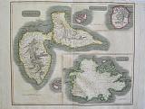
Islands of the West Indies: Porto Rico and the Virgin Islands with Haiti, St Domingo.
 Porto Rico and the Virgin Islands with Haiti, Hispaniola or St Domingo. "Porto Rico and the Virgin Islands; Haiti, Hispaniola or St Domingo" Edinburgh, London & Dublin John Thomson;Baldwin, Cradock, and Joy; John Cumming. 1817
Copper engraved map showing Porto Rico and the Virgin Islands with Haiti, St Domingo from Thomson's "A New General Atlas." Original outline colour; verso blank.
The large plate has two maps: Porto Rico and the Virgin islands to the upper part and Haiti below.
The map served as the source for Fielding Lucas. Good impression, generally clean & bright; general title in upper margin shaved; old ink number to upper right corner.
540 by 650mm (21¼ by 25½ inches). €400
Islands of the West Indies: St. Kitts & Nevis with St. Lucia.
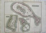 St. Kitts & Nevis with St. Lucia "St.Christophers; Nevis; St. Lucia." Edinburgh, London & Dublin John Thomson;Baldwin, Cradock, and Joy; John Cumming. 1817
Copper engraved map showing St Kitts & Nevis with St. Lucia from Thomson's "A New General Atlas." Original outline colour; verso blank.
The large plate has three maps on one plate: St. Kitts is depicted with inset smaller maps of Nevis and St. Lucia.
The map served as the source for Fielding Lucas. Good impression; short split at lower centrefold repaired with archival tape to verso; general title in upper margin; old ink number to upper right corner.
535 by 645mm (21 by 25½ inches). €200
The Island of Martinique.
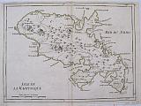 Martinique. "Isle de la Martinique." Paris Par le Sr le Rouge, rue des grands Augustins 1748
Copper engraved map of the island of Martinique from Le Rouge's "Atlas Nouveau portatif à l'usage des Militaires et du Voyageur" Original outline colour; verso blank Good impression; margins approx 5mm.
213 by 285mm (8½ by 11¼ inches). €80
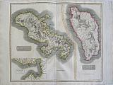
The Islands of Bermuda & Jamaica.
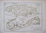 Bermuda. Jamaica. "La Jamaique aux anglois dans le Golfe du Mexique."; " La Bermude aux anglois" A Paris Par le Sr le Rouge, rue des grands Augustins 1748
Copper engraved maps [2 on 1 plate] of the island of Bermuda & Jamaica from Le Rouge's "Atlas Nouveau portatif à l'usage des Militaires et du Voyageur" Original outline colour; verso blank Good impression.
216 by 285mm (8½ by 11¼ inches). €250
Company: Bryan, Mary Louise.
Address: Ag. Andrianoy 92 , 21 100 Nafplio, Greece.
Vat No: EL 119092581