MAPS & VIEWS
PRINTS
BOOKS
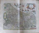
A Never Built Canal between The Rhine and Meuse; the Fossa Eugeniana.
 Fossa S. Mariæ, Quæ & Eugeniana dicta Rhenum Mosamque interduci cœpta anno 1628. "Fossa Sanctæ Mariæ, quæ et Eugeniana dictur Vulgo De Nieuwe Grista " Amsterdam Apud Guiljelmum et Joahannem Blaeu. 1647
Original coloured, copper engraved map of the Dutch provinces of Geldria & Zutphen from Blaeu's "Theatrum Orbis terrarum, sive atlas novus .Partis Prima pars Altera." Double page; folio; Latin text to verso.
Strap work title cartouche; decorative scale flanked by allegorical figures representing the Rhine and Meuse [ Moselle]; decorative dedicatory cartouche to the Infanta Isabellæ Claræ Eugenia of Spain flanked by spades and pickaxes; shields with coats of arms to upper corners; smaller coats of arms either side of Explicatio.
The map shows the Fossa Eugeniana, a never completed canal from the Rhine near Rheinberg to the Meuse near Venlo. Original colour; light damp stain to edges of blank margins.
Koeman1, Bl 23A. 385 by 510mm (15¼ by 20 inches). €400
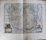
North West Flanders.
 Flandria Teutonicæ pars Orientalior. " Flandria Teutonicæ pars Orientalior." Amsterdam Apud Guiljelmum et Joahannem Blaeu. 1647
Original coloured, copper engraved map of North West Flanders from Blaeu's "Theatrum Orbis terrarum, sive atlas novus .Partis Prima pars Altera." Double page; folio; Latin text to verso.
Title cartouche surrounded by putti; compass rose and ships to sea
The map shows in detail the area of Ghent and Bruges in North West Flanders, and the coastline including part of Zeeland Bright original colour; light damp stain to lower edge of blank margin; small brown spot at foot of centre fold, far from image.
Koeman1, Bl 23A. 380 by 500mm (15 by 19¾ inches). €350
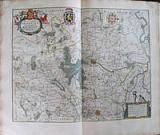
River maps: The Rhine and Meuse;
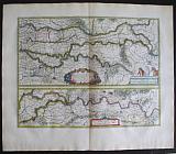 Batavia Vetus, sive Tractus Rheni, & Mosæ, Totiusque Vahallis, a divergio Rheni Gorcomium usque, cum terris adjacentibus Cliviæ, regno Neomgensi, & agro Bommeliano. "Tractus Rheni, & Mosæ, Totiusque Vahallis.... " Amsterdam Apud Guiljelmum et Joahannem Blaeu. 1647
Original coloured, copper engraved maps [2 on 1 plate] of the courses of the rivers Rhine and Meuse from Blaeu's "Theatrum Orbis terrarum, sive atlas novus .Partis Prima pars Altera." Double page; folio; Latin text to verso.
Strap work title cartouche to upper map, scale on plinth with figure and horses; strap work scale to lower map.
2 maps on one page showing the course of the major rivers Rhine, Waal and Maas from Gorinchem in the west to Rheinberck in Germany; the upper map shows the rivers from Gorinchem to Lobet and the lower map shows the continuation from Nijmegen to Rheinberck Original colour; light damp stain to edges of blank margins.
Koeman1, Bl 23A. 385 by 505mm (15¼ by 20 inches). €400
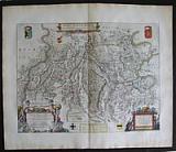
Decorative Map of Northern Brabant.
 Brabantia pars quarta;cujis caput Sylva-Ducis. "Quart Pars Brabantiæ cujus caput Silvaducis." Amsterdam Apud Guiljelmum et Joahannem Blaeu. 1647
Original coloured, copper engraved map of Northern Brabant from Blaeu's "Theatrum Orbis terrarum, sive atlas novus .Partis Prima pars Altera." Double page; folio; Latin text to verso.
Decorative title cartouche; two columns withmunicipal coats of arms to each side surmounted by putti; two large coats of arms of Brabant and 's-Hertogenbosch in each upper corner.
The map prepared by Willibrordus van der Burgt shows Northern Brabant with the capital 's-Hertogenbosch. Bright original colour; light damp stain to edge of lower blank margin; light spot to side blank margins, far from image.
Koeman1, Bl 23A. 412 by 526mm (16¼ by 20¾ inches). €550
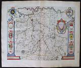
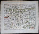
The Duchy of Brabant.
 Brabantia Ducatus. "Brabantia Ducatus." Amsterdam Apud Guiljelmum et Joahannem Blaeu. 1647
Original coloured, copper engraved map of the Duchy of Brabant from Blaeu's "Theatrum Orbis terrarum, sive atlas novus .Partis Prima pars Altera." Double page; folio; Latin text to verso.
Decorative title cartouche surmounted by figure and coat of arms; strapwork scale . Bright original colour; light damp stain to edge of lower blank margin also to upper right corner, far from image.
Koeman1, Bl 23A. 380 by 503mm (15 by 19¾ inches). €500
West Flanders, Dunkirk.
 Flandria Teutonicæ pars Occidentalior. " Flandria Teutonicæ pars Occidentalior." Amsterdam Apud Guiljelmum et Joahannem Blaeu. 1647
Original coloured, copper engraved map of West Flanders from Blaeu's "Theatrum Orbis terrarum, sive atlas novus .Partis Prima pars Altera." Double page; folio; Latin text to verso.
Title cartouche and scale surrounded by putti; compass rose and fleet of ships to sea
The map shows in detail the area of Dunkirk in West Flanders. Bright original colour; light damp stain to lower edge of blank margin; small brown spot at foot of centre fold, far from image.
Koeman1, Bl 23A. 393 by 5001mm (15½ by 197 inches). €350
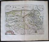
Bergen-op-Zoom and the Fortifications.
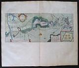 Descriptio Bergarum ad Zomam, Sterbergæ, & novorum ibi operum. "Tabula Bergarum ad Zomam, Sterbergæ, & novorum ibi operum." Amsterdam Apud Guiljelmum et Joahannem Blaeu. 1647
Original coloured, copper engraved map of the area round Bergen-op-Zoom from Blaeu's "Theatrum Orbis terrarum, sive atlas novus .Partis Prima pars Altera." Double page; folio; Latin text to verso.
Strap work title cartouche; inset of Castra Pinsii to lower right.
When the archduchess Isabella had the fortification Zandvliet between Bergen-op-Zoom and Antwerp provided with bullwarks and had a number of fortresses constructed along the Scheldt, the States General decided to construct the three fortresses of Moermont, Pinsen and de Roovere at dangerous points between the swamps to the north of Bergen-op-Zoom. Between these swamps were areas of higher ground over which the enemy could cross. The new line was supposed to protect Zeeland, the shipping routes between Zeeland and Holland, and the northern front of the city of Bergen against the enemy from the new line of defense in 1628 at the request of Prince Frederick Henry. Bright original colour; light damp stain to upper corners and edge of lower blank margin, far from image.
Koeman1, Bl 23A. 225 by 542mm (8¾ by 21¼ inches). €350
Brabant: Antwerp.
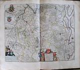 Tertia pars Brabantia civitas Antwerpia et Marchionatus S.R.Imperii. "Tertia pars Brabantia qua continetur Marchionat.S.R.I horum urbs primaria Antverpia.." Amsterdam Apud Guiljelmum et Joahannem Blaeu. 1647
Original coloured, copper engraved map of the area round Antwerp from Blaeu's "Theatrum Orbis terrarum, sive atlas novus .Partis Prima pars Altera." Double page; folio; Latin text to verso.
Decorative title cartouche surrounded by coats of arms; scale surmounted by figures of geographers; coats of arms upper right.
The map shows the area around Antwerp extending from Leuven at the left of plate, Antwerp at top, and Breda to the right of plate. Bright original colour; damp stain to upper corners, and edge of lower blank margin, far from image.
Koeman1, Bl 23A. 420 by 524mm (16½ by 20¾ inches). €300
Decorative Map of Holland and Belgium. The "Scheepjes Kaart".
 Germania Inferior, sive Belgica Hoderna "Novus XVII Inferioris Germaniae Provinciarum Typus" Amsterdam Apud Guiljelmum et Joahannem Blaeu. 1647
Original coloured, copper engraved map of the XVII Provinces from Blaeu's "Theatrum Orbis terrarum, sive atlas novus .Partis Prima pars Altera." Double page; folio; Latin text to verso.
Large decorative title cartouche, strap work scale and key; annotated compass rose; fleet of ships to coast.
The second state of the map, first published as a wall map in 1608 with figured borders. In 1630 Blaeu's sacrificed the borders [cutting them off the copper plate] to use as the general map of the Low countries in his first atlas The Appendix.
One of the most decorative maps of present Netherlands, Belgium and Luxembourg; with the signature of "Willem Janszoon op't Water in de Vergulde Zonnewyzer."
Bright original colour; light damp stain to edge of lower blank margin; printers crease at centre fold
Koeman1, Bl 23A. 397 by 505mm (15¾ by 20 inches). €1000
Bruxelle, Brussels.
 Brabantia pars secunda, cujus caput Bruxellæ. " Pars secunda Brabantia, cujus caput Bruxellæ." Amsterdam Apud Guiljelmum et Joahannem Blaeu. 1647
Original coloured, copper engraved map of the area around Brussels from Blaeu's "Theatrum Orbis terrarum, sive atlas novus .Partis Prima pars Altera." Double page; folio; Latin text to verso.
Decorative title cartouche surrounded by coats of arms; strap work scale surmounted by putti; coat of arms and compass rose.
The map shows the area around Brussels. Bright original colour; damp stain to upper corners, far from image.
Koeman1, Bl 21A. 412 by 274mm (16¼ by 10¾ inches). €300
Company: Bryan, Mary Louise.
Address: Ag. Andrianoy 92 , 21 100 Nafplio, Greece.
Vat No: EL 119092581